Pilt:Earth Western Hemisphere.jpg
Selle lehekülje sisule puudub teiste keelte tugi.
Läteq: Wikipedia

Algteedüstü(2048 × 2048 pikslit, 579 KB, MIME-tüüp: image/jpeg)

Seo om jaet teedüstü lättest Wikimedia Commons ja seod saa pruukiq ka tõisin projekten. Teedüstü seletüs om ant allpuul.

Kokkovõtõq

Seletüs
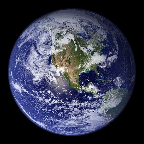
English: “Blue Marble”. Original caption:
Much of the information contained in this image came from a single remote-sensing device-NASA’s Moderate Resolution Imaging Spectroradiometer, or MODIS. Flying over 700 km above the Earth onboard the Terra satellite, MODIS provides an integrated tool for observing a variety of terrestrial, oceanic, and atmospheric features of the Earth. The land and coastal ocean portions of these images are based on surface observations collected from June through September 2001 and combined, or composited, every eight days to compensate for clouds that might block the sensor’s view of the surface on any single day. Two different types of ocean data were used in these images: shallow water true color data, and global ocean color (or chlorophyll) data. Topographic shading is based on the GTOPO 30 elevation dataset compiled by the U.S. Geological Survey’s EROS Data Center. MODIS observations of polar sea ice were combined with observations of Antarctica made by the National Oceanic and Atmospheric Administration’s AVHRR sensor—the Advanced Very High Resolution Radiometer. The cloud image is a composite of two days of imagery collected in visible light wavelengths and a third day of thermal infra-red imagery over the poles. Global city lights, derived from 9 months of observations from the Defense Meteorological Satellite Program, are superimposed on a darkened land surface map.
Kuupäiv
Läteq http://visibleearth.nasa.gov/view.php?id=57723
Tegijä
  • Reto Stöckli (land surface, shallow water, clouds)
  • Robert Simmon (enhancements: ocean color, compositing, 3D globes, animation)
  • Data and technical support: MODIS Land Group; MODIS Science Data Support Team; MODIS Atmosphere Group; MODIS Ocean Group
  • Additional data: USGS EROS Data Center (topography); USGS Terrestrial Remote Sensing Flagstaff Field Center (Antarctica); Defense Meteorological Satellite Program (city lights).
Teised versioonid Derivative works of this file:  Environment Barnstar new.png

Litsents

Public domain See fail on avalikus omandis, sest selle autori NASA autoriõiguspõhimõtte järgi ei ole ilma vastava märketa NASA materjalid autoriõigusega kaitstud. (NASA autoriõiguspõhimõtted või JPL-i piltide kasutuspõhimõtted).
Hoiatused:
  • NASA logode, ametlike märkide ja embleemide kasutamine on piiratud Ameerika Ühendriikide seadusega 14 CFR 1221.
  • NASA võrgukohas on üleval hulganisti Nõukogude/Vene kosmoseagentuuri ja muude mitte-Ameerika kosmoseagentuuride pilte, mis ei pruugi avalikus omandis olla.
  • Hubble'i teleskoobi materjalid võivad autoriõigusega kaitstud olla, kui nad ei pärine sõnaselgelt STScI-st. [1]
  • Automaatjaamaga SOHO tehtud materjalid on autoriõigusega kaitstud ja vajavad äriliseks mittehariduslikuks kasutuseks luba. [2]
  • Võrgulehel APOD kujutatud pildid võivad autoriõigusega kaitstud olla. [3]

Pealdised

Lisa üherealine seletus sellest, mida fail esitab

Selles failis kujutatud üksused

kujutab eesti

Sellel omadusel puudub väärtus

8. radokuu 2002

media type inglise

image/jpeg

Teedüstü aolugu

Klõpsaq kuupäävä/kelläao pääl, et nätäq määne taa teedüstü sis oll'.

Kuupäiv/KelläaigVäiku piltSuurusPruukjaSeletüs:
parhillanõ25. põimukuu 2005, kell 03:09Väiku pilt 25. põimukuu 2005, kell 03:09 kujolõ2048 × 2048 (579 KB)Tom{{PD-USGov-NASA}} http://earthobservatory.nasa.gov/Newsroom/BlueMarble/Images/globe_west_2048.jpg Much of the information contained in this image came from a single remote-sensing device-NASA’s Moderate Resolution Imaging Spectroradiometer, or MODIS.

Seod pilti pruugi-i ütski lehekülg.

Globaalne failipruukminõ

Järgmädseq muuq vikiq pruukvaq seod faili:

Kaeq seo faili vikidevaihõlist pruukmist.